Territory Borders
Geography: Minnesota Territory's Borders
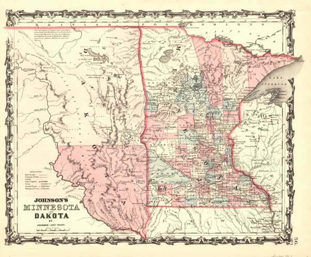
The Minnesota Territory, officially organized on March 3, 1849, included not only what would become the state of Minnesota, but extended west to the Missouri River and included the eastern portions of current-day North and South Dakota.
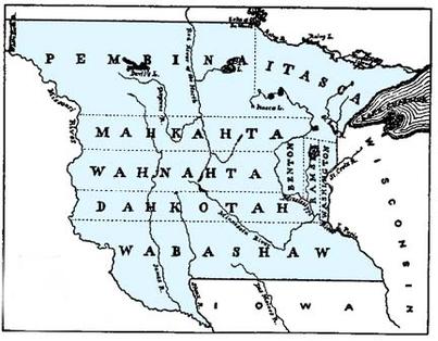
The territory included land east of the Mississippi ceded to the US from the British in 1783 and organized as the Northwest Territory in 1787. Land west of the Mississippi was acquired as a result of the Louisiana Purchase in 1803. In 1818, the Anglo-American conference agreed that, where no other agreements applied, the 49th parallel would form the northern boundary of US territories. That same year, the lavender areas on the map below were included in Michigan Territory. In 1834 Michigan Territory was expanded to include all of the highlighted areas.
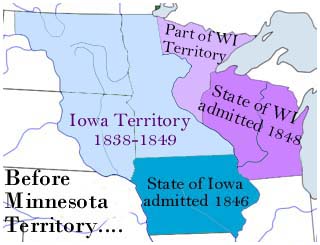
As Michigan prepared for statehood, territorial lands beyond its proposed boundaries were organized into the Wisconsin Territory in 1836. Just two years later, Wisconsin Territory was divided along the Mississippi, with Wisconsin Territory retaining lands east of the Mississippi and the area west of the Mississippi designated as the new Iowa Territory.
In the 1840's, Stephen Douglas was the chairman of the Senate Committee on Territories. In 1846, he blocked legislation that would have extended the northern border of Iowa to include Fort Snelling and St. Anthony. Likewise, when Wisconsin joined the union in 1848 it was Senator Douglas who blocked an attempt to set the Mississippi as the western border of that state instead of following the Mississippi only as far as the St. Croix River. Lands that were not included in the boundaries of these two states were consolidated into the Minnesota Territory.
The shape of the new state of Minnesota was a topic of much discussion and debate. A strong contingent argued that Minnesota should extend west to the Missouri River, with a northern border at the 46th parallel (a line that runs just north of Little Falls). Variations on this plan chose other degrees of latitude for the northern border. Others felt strongly that, rather than create a border using a man-made measure, the state's boundaries should follow rivers and lakes as closely as possible. Senator Stephen Douglas of Illinois and others wanted to use this first opportunity to apply the 49th parallel international border agreed upon with the British in 1818. Senator Douglas and his allies prevailed. The state stretches from Iowa in the south to the 49th parallel in the north. The western boundary of Minnesota was set by the Red River of the North. (The "Northwest Angle" that juts into Canada is the result of specific language in the 1783 Treaty of Paris.)
Minnesota became a state on May 11, 1858
As shown on the map to the right, the western part of the territory remained unorganized until 1861, when it became part of Dakota Territory.
Interested in learning more about the evolution of the borders of what would become Minnesota?
Click here for more information on the region's pre-1834 boundaries.